1965 Map of New Kent
USGS Topo · Published 1985About this map
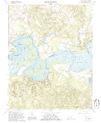
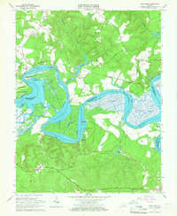
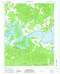
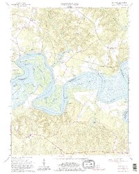
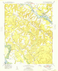
The Pamunkey River winds through a landscape defined by expansive tidal wetlands and small rural settlements in this mid-1960s survey. Significant land use is illustrated by the Pamunkey Indian Reservation situated along the river's bend, while the Southern railroad provides a critical transportation corridor passing through Lester Manor and Sweet Hall. Numerous small churches, including St Johns Ch, Bethany Ch, and New Elam Ch, serve as focal points for the surrounding communities, while the county seat at New Kent is represented by its courthouse and High Sch. The river itself is a complex network of waterways and marshlands, featuring named areas like Cousiac Marsh, Hill Marsh, and West Island. Riverside landings such as Brickhouse Landing and Morgan Landing suggest a persistent connection to the water, even as the landscape maintains its traditional agrarian and forested character.
Find a feature on this map
45 named features on this map. Tap any name to fly to it.
Don’t see what you’re looking for? This feature index may not catch every label — zoom into the map to look around manually.
Map Details
Editions of this 1965 New Kent Map
4 editions found
Other maps of this area

1917 · Toano
USGS Topo · 1:62,500

1918 · Charles City
USGS Topo · 1:62,500

1918 · Toano
USGS Topo · 1:62,500

1919 · New Kent
USGS Topo · 1:62,500

1920 · King William
USGS Topo · 1:62,500

1943 · Richmond
USGS Topo · 1:250,000

1949 · Truhart
USGS Topo · 1:24,000
1949 · King William
USGS Topo · 1:24,000

1949 · King And Queen
USGS Topo · 1:24,000

1949 · Tunstall
USGS Topo · 1:24,000