1973 Map of New Kent
USGS Topo · Published 1977About this map
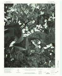
The wide, meandering course of the Pamunkey River dominates this landscape, defining the tidal character of Virginia's Tidewater region in the early 1970s. The aerial imagery captures the sharp contrast between the dense wooded wetlands along the riverbanks and the orderly patchwork of agricultural fields carved into the surrounding uplands. Near the southern edge of the sheet, the small settlement of New Kent serves as a focal point, marking a traditional crossroads in a largely rural landscape. This orthophotoquad provides a clear view of the land-use patterns before modern development intensified, showing how the local economy remained tied to the river and the soil. The intricate network of small farm roads and drainage patterns visible in the photo imagery offers researchers a direct view of the county's physical layout and property boundaries as they existed during this era.
Find a feature on this map
3 named features on this map. Tap any name to fly to it.
Don’t see what you’re looking for? This feature index may not catch every label — zoom into the map to look around manually.
Map Details
Editions of this 1973 New Kent Map
This is the sole edition of this map. No revisions or reprints were ever made.
Other maps of this area

1917 · Toano
USGS Topo · 1:62,500

1918 · Charles City
USGS Topo · 1:62,500

1918 · Toano
USGS Topo · 1:62,500

1919 · New Kent
USGS Topo · 1:62,500

1920 · King William
USGS Topo · 1:62,500

1943 · Richmond
USGS Topo · 1:250,000

1949 · Truhart
USGS Topo · 1:24,000
1949 · King William
USGS Topo · 1:24,000

1949 · King And Queen
USGS Topo · 1:24,000

1949 · Tunstall
USGS Topo · 1:24,000