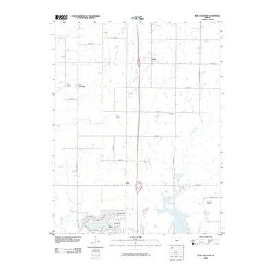
2009 Map of New Lancaster
USGS Topo · Published 2009About this map
Linn Valley stands as a primary residential center in this eastern Kansas landscape, characterized by a dense network of suburban streets such as Timber Valley Dr and Oak Crest Dr near the shores of La Cygnes Lake. The surrounding terrain transitions into traditional rural section lines, where smaller historic settlements like New Lancaster, Jingo, and Drexel Corner mark old crossroads. For local historians, these points of interest are often anchored by long-standing burial grounds including New Lancaster Cemetery and Jingo Cemetery. The region is defined by its watercourses, with Middle Creek and Elm Creek winding through the fields. Small-scale aviation is represented by private strips such as Hurt Airport and Jeserick Airport, reflecting the area's mix of residential development and agricultural utility.
Find a feature on this map
47 named features on this map. Tap any name to fly to it.
Don’t see what you’re looking for? This feature index may not catch every label — zoom into the map to look around manually.
Map Details
Editions of this 2009 New Lancaster Map
This is the sole edition of this map. No revisions or reprints were ever made.
Other maps of this area

1887 · Olathe
USGS Topo · 1:125,000

1887 · Mound City
USGS Topo · 1:125,000

1893 · Mound City
USGS Topo · 1:125,000

1893 · Olathe
USGS Topo · 1:125,000

1947 · Lawrence
USGS Topo · 1:250,000

1950 · Lawrence
USGS Topo · 1:250,000

1953 · Freeman
USGS Topo · 1:24,000

1956 · Paola East
USGS Topo · 1:24,000

1956 · Lawrence
USGS Topo · 1:250,000
1957 · Louisburg
USGS Topo · 1:24,000