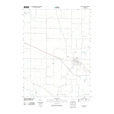
2010 Map of New London
USGS Topo · Published 2010About this map
New London serves as the central hub for this corner of Henry County, organized around the junction of major thoroughfares and the New London Post Office. The surrounding landscape is defined by a dense network of country roads following the section lines, including Oasis Ave, Nebraska Ave, and Racine Ave. This survey reveals a high concentration of family and community burial grounds, such as Ebeneezer Cemetery in the north and Beery Cemetery to the south, reflecting the deep-rooted agricultural settlement of the area.
Find a feature on this map
43 named features on this map. Tap any name to fly to it.
Don’t see what you’re looking for? This feature index may not catch every label — zoom into the map to look around manually.
Map Details
Editions of this 2010 New London Map
This is the sole edition of this map. No revisions or reprints were ever made.
Other maps of this area

1958 · Burlington
USGS Topo · 1:250,000

1958 · Davenport
USGS Topo · 1:250,000

1961 · Burlington
USGS Topo · 1:250,000

1961 · Davenport
USGS Topo · 1:250,000

1962 · Davenport
USGS Topo · 1:250,000

1963 · Burlington
USGS Topo · 1:250,000

1981 · Mount Pleasant
USGS Topo · 1:24,000
1981 · Danville
USGS Topo · 1:24,000
1981 · Morning Sun
USGS Topo · 1:24,000
1981 · Lowell
USGS Topo · 1:24,000