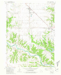
1981 Map of Danville
USGS Topo · Published 1981About this map
Danville and Middletown anchor this rural landscape in Des Moines County during the early 1980s, where the agricultural uplands transition toward the rugged valley of the Skunk River. The map reveals a dense network of local heritage sites, including family-named cemeteries such as Jaggar Cem and Blakeway Cem, and community centers like Harmony Ch and Long Creek Ch. The eastern edge is dominated by the sprawling Iowa Army Ammunition Plant, a massive installation that contrasts with the natural boundaries of Geode State Park to the west.
Find a feature on this map
42 named features on this map. Tap any name to fly to it.
Don’t see what you’re looking for? This feature index may not catch every label — zoom into the map to look around manually.
Map Details
Editions of this 1981 Danville Map
This is the sole edition of this map. No revisions or reprints were ever made.
Other maps of this area

1932 · Lomax
USGS Topo · 1:62,500

1934 · Burlington
USGS Topo · 1:48,000

1936 · Fort Madison
USGS Topo · 1:62,500

1937 · Lomax
USGS Topo · 1:62,500

1940 · Burlington
USGS Topo · 1:62,500

1958 · Burlington
USGS Topo · 1:250,000

1961 · Burlington
USGS Topo · 1:250,000

1963 · Burlington
USGS Topo · 1:250,000

1964 · West Point
USGS Topo · 1:24,000
1964 · West Burlington
USGS Topo · 1:24,000