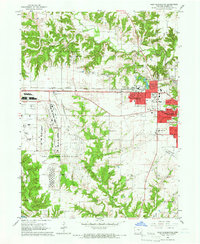
1964 Map of West Burlington
USGS Topo · Published 1965About this map
The Iowa Army Ammunition Plant dominates the southwestern portion of this mid-1960s landscape, illustrating the massive industrial and military footprint required for regional defense operations near the Mississippi River. Bordering this facility to the east is the expansion of West Burlington and the western edge of Burlington, where a tight grid of residential streets like Division St and Washington St meets the rural agricultural sections of Des Moines County.
Find a feature on this map
48 named features on this map. Tap any name to fly to it.
Don’t see what you’re looking for? This feature index may not catch every label — zoom into the map to look around manually.
Map Details
Editions of this 1964 West Burlington Map
2 editions found
Other maps of this area

1932 · Lomax
USGS Topo · 1:62,500

1934 · Burlington
USGS Topo · 1:48,000

1936 · Fort Madison
USGS Topo · 1:62,500

1937 · Lomax
USGS Topo · 1:62,500

1940 · Burlington
USGS Topo · 1:62,500

1958 · Burlington
USGS Topo · 1:250,000

1961 · Burlington
USGS Topo · 1:250,000

1963 · Burlington
USGS Topo · 1:250,000
1964 · Burlington
USGS Topo · 1:24,000

1964 · Lomax
USGS Topo · 1:24,000