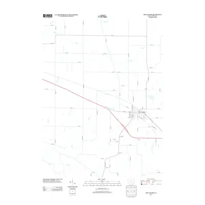
2013 Map of New London
USGS Topo · Published 2013About this map
New London serves as the central hub for this Henry County landscape, where the town's street grid meets the curving path of U.S. Route 34. The area is defined by a dense network of watercourses that drain the surrounding agricultural land, including the winding Big Cr and its various tributaries like N Br Big Cr and Lawrence Cr. The map details a transition from the structured residential blocks of the town, featuring streets like W Main St and S Elm St, into an expansive rural grid defined by gravel and paved roads. These rural routes, such as Quaker Ave and Nebraska Ave, connect the outlying homesteads to the municipal center. Smaller drainage features like Spearman Br, Brush Cr, and Dickey Br pattern the fields, illustrating the hydrology that has shaped the local farm economy and property boundaries for generations.
Find a feature on this map
61 named features on this map. Tap any name to fly to it.
Don’t see what you’re looking for? This feature index may not catch every label — zoom into the map to look around manually.
Map Details
Editions of this 2013 New London Map
This is the sole edition of this map. No revisions or reprints were ever made.
Other maps of this area

1958 · Burlington
USGS Topo · 1:250,000

1958 · Davenport
USGS Topo · 1:250,000

1961 · Burlington
USGS Topo · 1:250,000

1961 · Davenport
USGS Topo · 1:250,000

1962 · Davenport
USGS Topo · 1:250,000

1963 · Burlington
USGS Topo · 1:250,000

1981 · Mount Pleasant
USGS Topo · 1:24,000
1981 · Danville
USGS Topo · 1:24,000
1981 · Morning Sun
USGS Topo · 1:24,000
1981 · Lowell
USGS Topo · 1:24,000