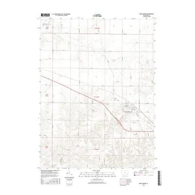
2015 Map of New London
USGS Topo · Published 2015About this map
New London stands as the primary hub of activity in this section of Henry County, Iowa, centered at the intersection of New London Rd and Old Hwy 34. The town's grid is well-defined by streets such as W Main St and E Adams St, illustrating a classic Midwestern settlement pattern surrounded by expansive agricultural lands. The township boundaries, including t71n r5w and t70n r5w, delineate the structured rural landscape where small settlements like Brooks are situated.
Find a feature on this map
47 named features on this map. Tap any name to fly to it.
Don’t see what you’re looking for? This feature index may not catch every label — zoom into the map to look around manually.
Map Details
Editions of this 2015 New London Map
This is the sole edition of this map. No revisions or reprints were ever made.
Other maps of this area

1958 · Burlington
USGS Topo · 1:250,000

1958 · Davenport
USGS Topo · 1:250,000

1961 · Burlington
USGS Topo · 1:250,000

1961 · Davenport
USGS Topo · 1:250,000

1962 · Davenport
USGS Topo · 1:250,000

1963 · Burlington
USGS Topo · 1:250,000

1981 · Mount Pleasant
USGS Topo · 1:24,000
1981 · Danville
USGS Topo · 1:24,000
1981 · Morning Sun
USGS Topo · 1:24,000
1981 · Lowell
USGS Topo · 1:24,000