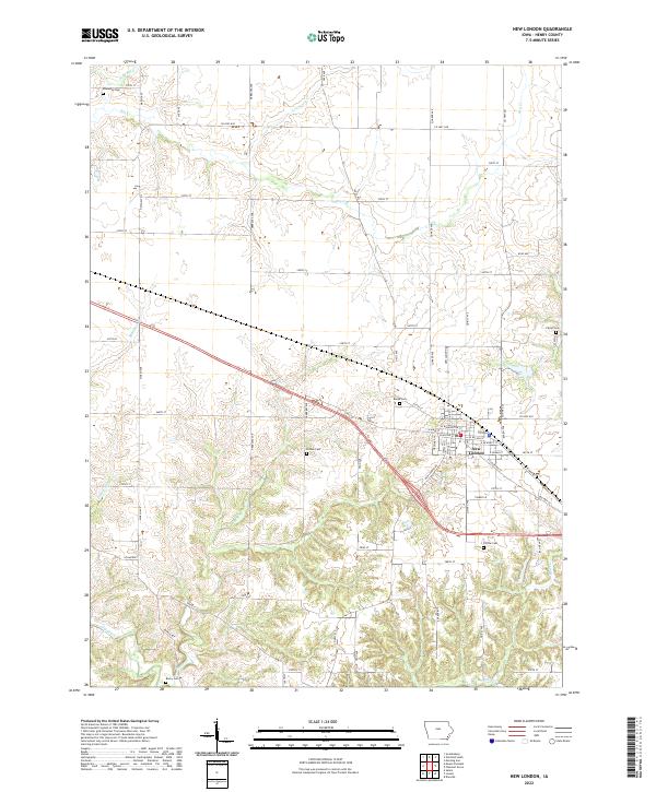
2022 Map of New London
USGS Topo · Published 2022About this map
New London serves as the primary urban center for this portion of Henry County, with its residential streets like W Washington St and E Cleveland St forming a structured grid amidst the surrounding agricultural landscape. The township is characterized by a high density of small family or community burial grounds, providing significant data points for genealogists. These sites, including Ebenezer Cem in the north and Beery Cem in the south, are often situated near the intricate drainage networks of Big Creek and its various tributaries like Brush Cr and Lawrence Cr. The terrain is defined by the erosion patterns of these waterways, which have carved modest valleys through the Iowa farmland, influencing the placement of secondary roads such as Oasis Ave and Quaker Ave as they navigate the shifting elevations of the local prairie.
Find a feature on this map
70 named features on this map. Tap any name to fly to it.
Don’t see what you’re looking for? This feature index may not catch every label — zoom into the map to look around manually.
Map Details
Editions of this 2022 New London Map
This is the sole edition of this map. No revisions or reprints were ever made.
Other maps of this area

1958 · Burlington
USGS Topo · 1:250,000

1958 · Davenport
USGS Topo · 1:250,000

1961 · Burlington
USGS Topo · 1:250,000

1961 · Davenport
USGS Topo · 1:250,000

1962 · Davenport
USGS Topo · 1:250,000

1963 · Burlington
USGS Topo · 1:250,000

1981 · Mount Pleasant
USGS Topo · 1:24,000
1981 · Danville
USGS Topo · 1:24,000
1981 · Morning Sun
USGS Topo · 1:24,000
1981 · Lowell
USGS Topo · 1:24,000