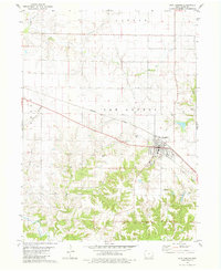
1981 Map of New London
USGS Topo · Published 1981About this map
New London serves as the primary hub of this Henry County landscape, where the Burlington Northern railroad cuts a diagonal line through the prairie. The settlement pattern is defined by rural townships including Canaan, New London, and Baltimore, with the small community of Canaan situated in the northern reaches. The area is heavily intersected by a network of waterways such as Big Creek, Lawrence Creek, and Spearman Branch, which dictate the local topography and agricultural drainage.
Find a feature on this map
22 named features on this map. Tap any name to fly to it.
Don’t see what you’re looking for? This feature index may not catch every label — zoom into the map to look around manually.
Map Details
Editions of this 1981 New London Map
This is the sole edition of this map. No revisions or reprints were ever made.
Other maps of this area

1958 · Burlington
USGS Topo · 1:250,000

1958 · Davenport
USGS Topo · 1:250,000

1961 · Burlington
USGS Topo · 1:250,000

1961 · Davenport
USGS Topo · 1:250,000

1962 · Davenport
USGS Topo · 1:250,000

1963 · Burlington
USGS Topo · 1:250,000

1981 · Mount Pleasant
USGS Topo · 1:24,000
1981 · Danville
USGS Topo · 1:24,000
1981 · Morning Sun
USGS Topo · 1:24,000
1981 · Lowell
USGS Topo · 1:24,000