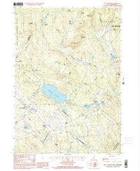
1998 Map of New London
USGS Topo · Published 2001About this map
New London serves as the focal point of this Merrimack County landscape, where the campus of Colby Jr College is established near the hills above Pleasant Lake. The late-twentieth-century terrain is defined by a dense network of conservation lands and managed forests, including the Gile State Memorial Forest and the Colby Town Sanctuary, reflecting a transition from the area's industrial past toward recreation and preservation. Small settlements like Elkins, Wilmot Flat, and South Danbury (Converse Sta) cluster along the brooks and crossroads, while local heritage is preserved in sites like Scytheville Town Park. Numerous water bodies such as Eagle Pond and Tannery Pond are connected by a web of mountain streams like Frazier Brook and Cascade Brook, framing the various hills and ridges that dominate the New Hampshire uplands.
Find a feature on this map
67 named features on this map. Tap any name to fly to it.
Don’t see what you’re looking for? This feature index may not catch every label — zoom into the map to look around manually.
Map Details
Editions of this 1998 New London Map
This is the sole edition of this map. No revisions or reprints were ever made.
Other maps of this area

1902 · Sunapee
USGS Topo · 1:62,500

1905 · Sunapee
USGS Topo · 1:62,500

1907 · Sunapee
USGS Topo · 1:62,500

1927 · Cardigan
USGS Topo · 1:62,500

1927 · Mascoma
USGS Topo · 1:62,500

1928 · Mount Kearsarge
USGS Topo · 1:62,500

1930 · Cardigan
USGS Topo · 1:62,500

1931 · Mount Kearsarge
USGS Topo · 1:62,500

1932 · Mascoma
USGS Topo · 1:62,500

1949 · Portland
USGS Topo · 1:250,000