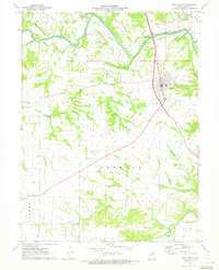
1971 Map of New London
USGS Topo · Published 1973About this map
New London serves as the focal point of this Ralls County survey, situated just south of the winding Salt River. The landscape is defined by the intersection of early transportation and agricultural life, evidenced by the prominent Old Railroad Grade and numerous rural landmarks. Genealogists will find a high concentration of small family and community burial grounds, including Barkley Cem, Pleasant View Cem, and Flowerree Cem, which are scattered throughout the townships of Spencer and Center. To the west, the terrain becomes more varied near Turkey Creek, where unique geological features such as Butler Cave and Buford Cave are documented. This record illustrates the mid-century rural Missouri landscape, where country churches like Bethel Ch and Salem Ch acted as social anchors for the surrounding farmstead networks.
Find a feature on this map
30 named features on this map. Tap any name to fly to it.
Don’t see what you’re looking for? This feature index may not catch every label — zoom into the map to look around manually.
Map Details
Editions of this 1971 New London Map
This is the sole edition of this map. No revisions or reprints were ever made.
Other maps of this area

1890 · Louisiana
USGS Topo · 1:125,000

1890 · Mexico
USGS Topo · 1:125,000

1903 · Palmyra
USGS Topo · 1:125,000

1932 · Hannibal
USGS Topo · 1:62,500

1936 · Hannibal
USGS Topo · 1:48,000

1943 · Vandalia
USGS Topo · 1:62,500

1945 · Hannibal
USGS Topo · 1:62,500

1945 · Perry
USGS Topo · 1:62,500

1945 · Vandalia
USGS Topo · 1:62,500

1948 · Quincy
USGS Topo · 1:250,000