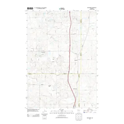
2013 Map of New Market
USGS Topo · Published 2013About this map
The Vermillion River headwaters and a unique agricultural-to-suburban landscape define this portion of Scott and Rice Counties. This 2013 survey documents the distinct neighboring centers of New Market and Elko, just before their formal merger, alongside the smaller communities of Eidswold, Webster, and Hazelwood. The area retains a strong rural character, evidenced by Nelson's Apple Farm and the W Christiania Cem, while aviation interests are represented by the Sky Harbor Residential Airpark. Notable water bodies include Rice Lake, Sweetbrier Lake, and the Pettit Wildlife Pond, illustrating the glacial topography of the region. The map also traces the historic path of Dodd Blvd, a vital artery through the South Metro since the mid-19th century.
Find a feature on this map
91 named features on this map. Tap any name to fly to it.
Don’t see what you’re looking for? This feature index may not catch every label — zoom into the map to look around manually.
Map Details
Editions of this 2013 New Market Map
This is the sole edition of this map. No revisions or reprints were ever made.
Other maps of this area

1953 · Saint Paul
USGS Topo · 1:250,000

1957 · Farmington
USGS Topo · 1:62,500

1957 · Prior Lake
USGS Topo · 1:62,500

1959 · Saint Paul
USGS Topo · 1:250,000

1960 · Northfield
USGS Topo · 1:24,000

1960 · Lonsdale
USGS Topo · 1:24,000

1960 · Little Chicago
USGS Topo · 1:24,000
1974 · Prior Lake
USGS Topo · 1:24,000
1974 · New Market
USGS Topo · 1:24,000
1974 · Veseli
USGS Topo · 1:24,000