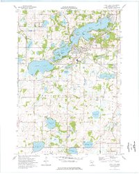
1974 Map of Prior Lake
USGS Topo · Published 1976About this map
Prior Lake Indian Res sits at the heart of this landscape, nestled among a sprawling system of glacial lakes that defined the region's development during the 1970s. The interconnected waters of Lower Prior Lake and Upper Prior Lake separate the established community of Prior Lake from smaller settlements like Grainwood and the northern reach of Shakopee. This survey captures the transition of the area into a suburban and recreational hub, evidenced by the Drive-in Theater and the Franciscan Retreat Center. Transport and industry are marked by the Chicago Milwaukee St Paul and Pacific railroad line, while several cemeteries, including St Michaels Cem and Concord Cem, provide critical points of interest for genealogists tracing families in Scott County. Farther south, the terrain becomes more rural, punctuated by named bodies of water like Fish Lake and Cynthia Lake.
Find a feature on this map
48 named features on this map. Tap any name to fly to it.
Don’t see what you’re looking for? This feature index may not catch every label — zoom into the map to look around manually.
Map Details
Editions of this 1974 Prior Lake Map
2 editions found
Other maps of this area

1896 · Minneapolis
USGS Topo · 1:62,500

1901 · Minneapolis
USGS Topo · 1:62,500

1905 · Minnetonka
USGS Topo · 1:62,500

1907 · Minnetonka
USGS Topo · 1:62,500

1953 · Saint Paul
USGS Topo · 1:250,000

1954 · Bloomington
USGS Topo · 1:24,000

1954 · Eden Prairie
USGS Topo · 1:24,000

1954 · Minneapolis
USGS Topo · 1:62,500

1957 · Prior Lake
USGS Topo · 1:62,500

1957 · New Prague
USGS Topo · 1:62,500