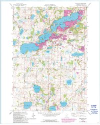
1974 Map of Prior Lake
USGS Topo · Published 1994About this map
Lower Prior Lake and Upper Prior Lake anchor this landscape south of the Twin Cities, where post-war suburban expansion begins to meet established agricultural and tribal lands. The map details the complex shoreline of these water bodies, featuring Martinson Island and Lone Tree Island, alongside the growing corporate boundaries of Prior Lake. Cultural and religious landmarks are well-represented, from the Franciscan Retreat Center to the Prior Lake Ind Res, reflecting the diverse community history of the region.
Find a feature on this map
42 named features on this map. Tap any name to fly to it.
Don’t see what you’re looking for? This feature index may not catch every label — zoom into the map to look around manually.
Map Details
Editions of this 1974 Prior Lake Map
2 editions found
Other maps of this area

1896 · Minneapolis
USGS Topo · 1:62,500

1901 · Minneapolis
USGS Topo · 1:62,500

1905 · Minnetonka
USGS Topo · 1:62,500

1907 · Minnetonka
USGS Topo · 1:62,500

1953 · Saint Paul
USGS Topo · 1:250,000

1954 · Bloomington
USGS Topo · 1:24,000

1954 · Eden Prairie
USGS Topo · 1:24,000

1954 · Minneapolis
USGS Topo · 1:62,500

1957 · Prior Lake
USGS Topo · 1:62,500

1957 · New Prague
USGS Topo · 1:62,500