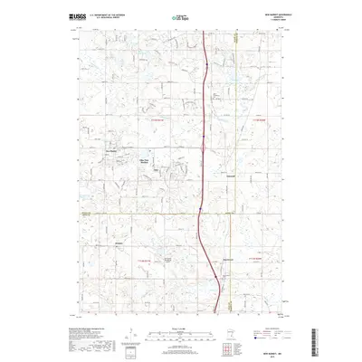
2019 Map of New Market
USGS Topo · Published 2019About this map
Elko New Market and the surrounding townships in Scott, Dakota, and Rice counties are documented here in detail, showcasing a landscape of established rural settlements and evolving suburban infrastructure. The map reveals the distinct historic nodes of New Market, Elko, and the unincorporated community of Eidswold, while tracing the meandering path of the Vermillion River as it cuts across the northern half of the sheet. Genealogical value is found in the locations of the West Christiania Cem and Annunciation Cem, which serve as landmarks for the area's early congregations. To the south, the village of Webster sits near the headwaters of Porter Cr, illustrating the region's reliance on small waterways. A modern addition to the landscape is the Sky Harbor Residential Airpark, indicating the integration of specialized aviation-centered residential planning within this traditionally agricultural zone.
Find a feature on this map
63 named features on this map. Tap any name to fly to it.
Don’t see what you’re looking for? This feature index may not catch every label — zoom into the map to look around manually.
Map Details
Editions of this 2019 New Market Map
This is the sole edition of this map. No revisions or reprints were ever made.
Other maps of this area

1953 · Saint Paul
USGS Topo · 1:250,000

1957 · Farmington
USGS Topo · 1:62,500

1957 · Prior Lake
USGS Topo · 1:62,500

1959 · Saint Paul
USGS Topo · 1:250,000

1960 · Northfield
USGS Topo · 1:24,000

1960 · Lonsdale
USGS Topo · 1:24,000

1960 · Little Chicago
USGS Topo · 1:24,000
1974 · Prior Lake
USGS Topo · 1:24,000
1974 · New Market
USGS Topo · 1:24,000
1974 · Veseli
USGS Topo · 1:24,000