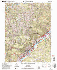
2002 Map of New Matamoras
USGS Topo · Published 2006About this map
New Matamoras and Sistersville anchor this reach of the Ohio River at the start of the 21st century, showing the enduring river-town character of the border between Ohio and West Virginia. Much of the western interior is occupied by the Wayne National Forest, where steep ridges like Greenbrier Ridge and Clark Ridge are dissected by countless runs. Small, isolated settlements such as Jericho, Poulton, and Brownsville dot the uplands, often centered around landmarks like Salem Hall or Washington Hall. The river itself is a focal point for conservation and recreation, featuring the Ohio River Islands National Wildlife Refuge and several large islands, including Wells Island and Grandview Island. Traces of local industry appear at the Sand and Gravel Pits near Grandview, while the Ring Mill Canoe Access provides a modern recreational link to the Little Muskingum River.
Find a feature on this map
47 named features on this map. Tap any name to fly to it.
Don’t see what you’re looking for? This feature index may not catch every label — zoom into the map to look around manually.
Map Details
Editions of this 2002 New Matamoras Map
This is the sole edition of this map. No revisions or reprints were ever made.
Other maps of this area

1905 · West Union
USGS Topo · 1:62,500

1905 · New Matamoras
USGS Topo · 1:62,500

1906 · Saint Marys
USGS Topo · 1:62,500

1906 · New Martinsville
USGS Topo · 1:62,500

1924 · St Marys
USGS Topo · 1:62,500

1924 · New Martinsville
USGS Topo · 1:62,500

1924 · New Matamoras
USGS Topo · 1:62,500

1924 · West Union
USGS Topo · 1:62,500

1926 · New Martinsville
USGS Topo · 1:62,500

1926 · New Matamoras
USGS Topo · 1:62,500