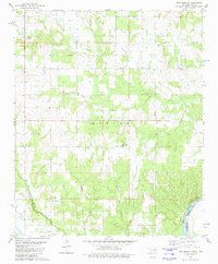
1980 Map of New Oberlin
USGS Topo · Published 1981About this map
New Oberlin and the neighboring settlement of Oberlin sit just north of the Red River in this detailed survey of southern Choctaw County. The landscape is defined by the winding paths of several watercourses, including Whitegrass Creek, Lick Creek, and Rock Creek, which drain toward the Texas border. The map provides significant genealogical value, documenting several rural burial sites such as Crowder Cem and Crowder Springs Cem, as well as the local Iron Stob Ch.
Find a feature on this map
19 named features on this map. Tap any name to fly to it.
Don’t see what you’re looking for? This feature index may not catch every label — zoom into the map to look around manually.
Map Details
Editions of this 1980 New Oberlin Map
This is the sole edition of this map. No revisions or reprints were ever made.
Other maps of this area

1901 · Antlers
USGS Topo · 1:125,000

1903 · Paris
USGS Topo · 1:125,000

1912 · Antlers
USGS Topo · 1:125,000

1925 · Antlers
USGS Topo · 1:125,000

1948 · Grant
USGS Topo · 1:62,500

1948 · Direct
USGS Topo · 1:62,500

1949 · Direct
USGS Topo · 1:62,500

1949 · Grant
USGS Topo · 1:62,500

1950 · Mcalester
USGS Topo · 1:250,000

1953 · Texarkana
USGS Topo · 1:250,000