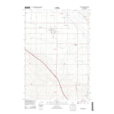
2013 Map of New Plymouth
USGS Topo · Published 2013About this map
New Plymouth serves as the focal point of this irrigation-shaped landscape in the Lower Payette Valley. This particular layout is notable for its horseshoe-shaped boulevard system, including SW Boulevard and SE Boulevard, which differentiates it from the typical grid iron patterns of neighboring Western towns. The surrounding area is defined by an extensive network of water management, where the Payette River feeds essential arteries like the Noble Canal, Farmers Cooperative Canal, and the A Line Canal.
Find a feature on this map
57 named features on this map. Tap any name to fly to it.
Don’t see what you’re looking for? This feature index may not catch every label — zoom into the map to look around manually.
Map Details
Editions of this 2013 New Plymouth Map
This is the sole edition of this map. No revisions or reprints were ever made.
Other maps of this area

1897 · Weiser
USGS Topo · 1:125,000

1898 · Nampa
USGS Topo · 1:125,000

1951 · Payette
USGS Topo · 1:24,000

1952 · Birding Island
USGS Topo · 1:24,000

1955 · Baker
USGS Topo · 1:250,000

1955 · Boise
USGS Topo · 1:250,000

1958 · Boise
USGS Topo · 1:250,000

1959 · Baker
USGS Topo · 1:250,000

1962 · Boise
USGS Topo · 1:250,000
1965 · Nyssa
USGS Topo · 1:24,000