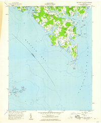
1957 Map of New Point Comfort
USGS Topo · Published 1960About this map
Lighthouse New Point Comfort stands as the sentinel of this coastal landscape, marking the southern tip of a peninsula where the Chesapeake Bay meets Mobjack Bay. This 1957 survey captures a maritime community defined by its intricate shoreline, where small settlements like Susan, Bavon, and Motorun are linked by winding roads across tidal flats. The geography reflects a deep reliance on the water, evidenced by Diggs Wharf and West Landing along the East River, alongside numerous small creeks such as Pepper Creek and Horn Harbor that carve into Potato Neck. Social life in the mid-20th century is anchored by several local congregations, including Antioch Ch and St Mathews Ch, and the New Point Sch. The map also includes the isolated Guinea Marshes and Sheep Island, illustrating the shifting transition between the mainland and the open bay before significant modern development altered these low-lying reaches.
Find a feature on this map
41 named features on this map. Tap any name to fly to it.
Don’t see what you’re looking for? This feature index may not catch every label — zoom into the map to look around manually.
Map Details
Editions of this 1957 New Point Comfort Map
This is the sole edition of this map. No revisions or reprints were ever made.
Other maps of this area

1907 · Hampton
USGS Topo · 1:62,500

1916 · Mathews
USGS Topo · 1:62,500

1917 · Mathews
USGS Topo · 1:62,500

1943 · Richmond
USGS Topo · 1:250,000

1944 · Messick
USGS Topo · 1:24,000

1944 · Harris Grove
USGS Topo · 1:24,000

1948 · Ware Neck
USGS Topo · 1:24,000

1948 · Achilles
USGS Topo · 1:24,000

1948 · New Point Comfort
USGS Topo · 1:24,000

1948 · Mathews
USGS Topo · 1:24,000