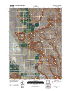
2011 Map of New Princeton
USGS Topo · Published 2011About this map
Harney Valley transitions into the high desert breaks of eastern Oregon in this digital-age survey, where the small community of New Princeton serves as a central hub for the surrounding ranching country. The landscape is defined by its water management and distinct topographic landmarks, including the Oron Thompson Reservoir and prominent volcanic features like Hatt Butte and Windy Point. Settlement patterns are sparse and tied closely to the land, with the Thompson Ranch and Beckley Ranch anchoring the local geography. Transportation in this corner of the state relies on a network of straight-line desert roads such as Lava Bed Rd and the Narrows-Princeton Rd, which navigate the passage between Pelican Point and the Malheur Gap. The map illustrates the specialized cattle-country economy of the early 21st century, where vast areas like the Beaver Tables remain largely open range.
Find a feature on this map
14 named features on this map. Tap any name to fly to it.
Don’t see what you’re looking for? This feature index may not catch every label — zoom into the map to look around manually.
Map Details
Editions of this 2011 New Princeton Map
This is the sole edition of this map. No revisions or reprints were ever made.
Other maps of this area

1955 · Burns
USGS Topo · 1:250,000

1958 · Burns
USGS Topo · 1:250,000

1959 · Burns
USGS Topo · 1:250,000

1960 · Crane
USGS Topo · 1:62,500

1967 · Barton Lake
USGS Topo · 1:24,000

1967 · Adobe Flat
USGS Topo · 1:24,000

1968 · Venator
USGS Topo · 1:62,500

1972 · Circle Bar
USGS Topo · 1:24,000
1972 · Tin Can Ridge
USGS Topo · 1:24,000

1974 · Anderson Mtn
USGS Topo · 1:62,500