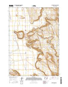
2017 Map of New Princeton
USGS Topo · Published 2017About this map
New Princeton anchors this high-desert landscape in Harney County, where the agricultural and ranching infrastructure of the basin meets dramatic geological rises. The settlement is positioned along a network of rural routes including Lava Bed Rd and Narrows-Princeton Rd, illustrating the importance of road connectivity in this expansive region. To the north, the terrain is defined by distinct landmarks such as Windy Point and Pelican Point, with the Windy Point Cem serving as a significant site for local genealogical research.
Find a feature on this map
24 named features on this map. Tap any name to fly to it.
Don’t see what you’re looking for? This feature index may not catch every label — zoom into the map to look around manually.
Map Details
Editions of this 2017 New Princeton Map
This is the sole edition of this map. No revisions or reprints were ever made.
Other maps of this area

1955 · Burns
USGS Topo · 1:250,000

1958 · Burns
USGS Topo · 1:250,000

1959 · Burns
USGS Topo · 1:250,000

1960 · Crane
USGS Topo · 1:62,500

1967 · Barton Lake
USGS Topo · 1:24,000

1967 · Adobe Flat
USGS Topo · 1:24,000

1968 · Venator
USGS Topo · 1:62,500

1972 · Circle Bar
USGS Topo · 1:24,000
1972 · Tin Can Ridge
USGS Topo · 1:24,000

1974 · Anderson Mtn
USGS Topo · 1:62,500