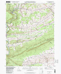
1997 Map of New Ringgold
USGS Topo · Published 1998About this map
Blue Mountain dominates this late-twentieth-century landscape, providing a high-elevation corridor for the Appalachian Trail as it winds past landmarks like Dans Pulpit and Owls Head. The map highlights the intersection of protected natural spaces and small rural settlements, with the renowned Hawk Mountain Sanctuary and several expansive State Game Lands No 106 parcels preserving the terrain. Below the ridgeline, the Little Schuylkill River carves through the valley near New Ringgold, where an Old RR Grade hints at the area’s industrial past.
Find a feature on this map
50 named features on this map. Tap any name to fly to it.
Don’t see what you’re looking for? This feature index may not catch every label — zoom into the map to look around manually.
Map Details
Editions of this 1997 New Ringgold Map
This is the sole edition of this map. No revisions or reprints were ever made.
Other maps of this area

1889 · Hazleton
USGS Topo · 1:62,500

1889 · Pottsville
USGS Topo · 1:62,500

1891 · Hazleton
USGS Topo · 1:62,500

1891 · Pottsville
USGS Topo · 1:62,500

1892 · Mahanoy
USGS Topo · 1:62,500

1893 · Hazleton
USGS Topo · 1:62,500

1893 · Mahanoy
USGS Topo · 1:62,500

1909 · Hamburg
USGS Topo · 1:62,500

1911 · Hamburg
USGS Topo · 1:62,500

1944 · Orwigsburg
USGS Topo · 1:24,000
Featured Places
- West Penn Township, PA
- Albany Township, PA
- New Ringgold, PA
- Kepner, West Penn Township
- West Brunswick Township, PA