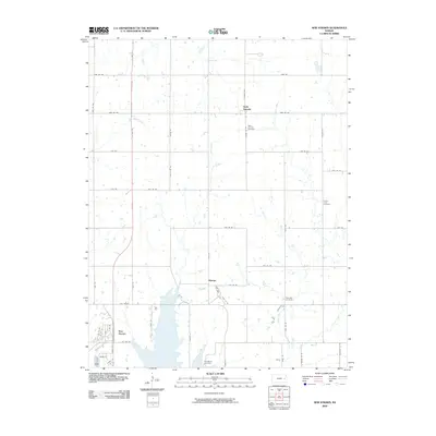
2009 Map of New Strawn
USGS Topo · Published 2009About this map
New Strawn and the surrounding prairie of Coffey County are defined by a strictly surveyed grid of section roads and the meandering courses of Wolf Creek and Long Creek. Located at the intersection of US Hwy 75 and the 17th Road corridor, this area includes the rural settlements of Sharpe and Halls Summit. The landscape is dotted with small farm ponds and local burial grounds that reflect the long-standing community structure of the region, including Halls Summit Cemetery, Prairie View Cemetery, and Glendale Cemetery. Farther south, near the modern street layouts of New Strawn, the Stringtown Cemetery preserves a link to earlier pioneer history. The map illustrates a transitional rural landscape where traditional homesteads and creek-bottom timber meet the expanding infrastructure of the early 21st century.
Find a feature on this map
53 named features on this map. Tap any name to fly to it.
Don’t see what you’re looking for? This feature index may not catch every label — zoom into the map to look around manually.
Map Details
Editions of this 2009 New Strawn Map
This is the sole edition of this map. No revisions or reprints were ever made.
Other maps of this area

1885 · Burlington
USGS Topo · 1:125,000

1894 · Burlington
USGS Topo · 1:125,000

1947 · Lawrence
USGS Topo · 1:250,000

1950 · Lawrence
USGS Topo · 1:250,000

1956 · Lawrence
USGS Topo · 1:250,000

1957 · Lebo
USGS Topo · 1:24,000

1957 · Waverly NW
USGS Topo · 1:24,000

1957 · Waverly
USGS Topo · 1:24,000

1961 · Lawrence
USGS Topo · 1:250,000
1966 · John Redmond Dam
USGS Topo · 1:24,000