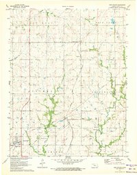
1971 Map of New Strawn
USGS Topo · Published 1973About this map
Halls Summit and the small settlement of Sharpe occupy the central corridor of this Coffey County landscape, situated along the Atchison Topeka And Santa Fe railroad. The era of this survey reflects a period of infrastructure development, evidenced by the modern layout of New Strawn in the southwest and the presence of a Landing Strip and multiple utility pipelines. The terrain is defined by the winding paths of Wolf Creek and Long Creek, which drain the surrounding agricultural uplands.
Find a feature on this map
23 named features on this map. Tap any name to fly to it.
Don’t see what you’re looking for? This feature index may not catch every label — zoom into the map to look around manually.
Map Details
Editions of this 1971 New Strawn Map
This is the sole edition of this map. No revisions or reprints were ever made.
Other maps of this area

1885 · Burlington
USGS Topo · 1:125,000

1894 · Burlington
USGS Topo · 1:125,000

1947 · Lawrence
USGS Topo · 1:250,000

1950 · Lawrence
USGS Topo · 1:250,000

1956 · Lawrence
USGS Topo · 1:250,000

1957 · Lebo
USGS Topo · 1:24,000

1957 · Waverly NW
USGS Topo · 1:24,000

1957 · Waverly
USGS Topo · 1:24,000

1961 · Lawrence
USGS Topo · 1:250,000
1966 · John Redmond Dam
USGS Topo · 1:24,000