
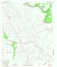
1960 Map of New Taiton
USGS Topo · Published 1961About this map
New Taiton serves as the central hub of this coastal prairie landscape, captured during a period of significant energy development and agricultural activity. The map reveals a complex network of pipelines and oil infrastructure, most notably within the New Taiton Oil Field to the north and the Lakeview Oil Field further south. These industrial features are juxtaposed against the community’s social foundations, including St John Ch, which remains a prominent landmark in the local genealogy.
Find a feature on this map
16 named features on this map. Tap any name to fly to it.
Don’t see what you’re looking for? This feature index may not catch every label — zoom into the map to look around manually.
Map Details
Editions of this 1960 New Taiton Map
2 editions found
Other maps of this area

1952 · Pierce
USGS Topo · 1:24,000

1952 · Egypt
USGS Topo · 1:24,000

1953 · Glen Flora
USGS Topo · 1:24,000

1953 · Seguin
USGS Topo · 1:250,000

1958 · Seguin
USGS Topo · 1:250,000

1959 · Garwood
USGS Topo · 1:24,000

1959 · Bonus
USGS Topo · 1:24,000

1965 · El Campo
USGS Topo · 1:24,000

1965 · Gobbler Creek
USGS Topo · 1:24,000
1965 · Hahn
USGS Topo · 1:24,000