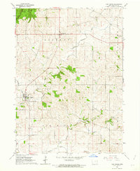
1962 Map of New Vienna
USGS Topo · Published 1963About this map
White Pine Hollow State Park and the rugged Pine Hollow terrain dominate the northwestern corner of this Dubuque County landscape, providing a sharp contrast to the surrounding agricultural uplands. The drainage of the North Fork Maquoketa River carves through the central portion of the map, while its tributaries like Coffie Creek, Hickory Creek, and Hewitt Creek define the local topography. This 1962 field-checked survey documents the established settlements of New Vienna and Luxemburg, reflecting the area's deep-rooted Catholic heritage through the prominent placement of Cem sites and ecclesiastical structures within the town centers. Small-scale industrial activity is evidenced by scattered Quarry sites and Gravel Pits, which supported local infrastructure as the region continued its transition into the mid-20th century. The map also delineates the civil townships of Liberty, Concord, and New Wine, illustrating the administrative organization of the Iowa countryside.
Find a feature on this map
15 named features on this map. Tap any name to fly to it.
Don’t see what you’re looking for? This feature index may not catch every label — zoom into the map to look around manually.
Map Details
Editions of this 1962 New Vienna Map
This is the sole edition of this map. No revisions or reprints were ever made.
Other maps of this area

1900 · Anamosa
USGS Topo · 1:125,000

1900 · Lancaster
USGS Topo · 1:125,000

1901 · Peosta
USGS Topo · 1:125,000

1902 · Elkader
USGS Topo · 1:125,000

1904 · Lancaster
USGS Topo · 1:125,000

1908 · Lancaster
USGS Topo · 1:125,000

1955 · Cassville
USGS Topo · 1:24,000

1957 · Turkey River
USGS Topo · 1:24,000

1957 · Colesburg
USGS Topo · 1:24,000

1957 · Holy Cross
USGS Topo · 1:24,000