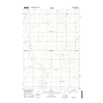
2015 Map of Newark
USGS Topo · Published 2015About this map
Brampton and Newark anchor this prairie landscape along the border of North Dakota and South Dakota. In the northern reaches, the Brampton Cem serves as a significant genealogical landmark for the surrounding township. The terrain is defined by a dense network of sectional roads, including 98th St SE and 104th St, which organize the agricultural lands of Sargent County and Marshall County. The southern portion of the map features the Westwood Colony, reflecting the communal settlement patterns found in this region. The map details a landscape characterized by numerous small depressions and seasonal water bodies typical of the glaciated plains, intersected by arterial routes like Newark Rd that connect these remote settlements across the state line.
Find a feature on this map
21 named features on this map. Tap any name to fly to it.
Don’t see what you’re looking for? This feature index may not catch every label — zoom into the map to look around manually.
Map Details
Editions of this 2015 Newark Map
This is the sole edition of this map. No revisions or reprints were ever made.
Other maps of this area

1953 · Britton East
USGS Topo · 1:24,000

1953 · Newark SW
USGS Topo · 1:24,000

1953 · Kidder
USGS Topo · 1:24,000

1953 · Newark
USGS Topo · 1:24,000

1953 · Milbank
USGS Topo · 1:250,000

1953 · Fargo
USGS Topo · 1:250,000

1956 · Fargo
USGS Topo · 1:250,000
1956 · Straubville
USGS Topo · 1:24,000

1956 · Britton West
USGS Topo · 1:24,000

1956 · Newark NW
USGS Topo · 1:24,000