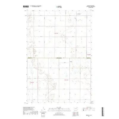
2017 Map of Newark
USGS Topo · Published 2017About this map
Brampton and Newark sit along the border of North and South Dakota, illustrating the enduring grid of the Public Land Survey System. The landscape is defined by the Sargent County and Marshall County line, which also serves as the state boundary. Local history is centered around the small settlement of Brampton in the north and the Brampton Cem nearby, which provides a focal point for genealogical research in this rural prairie region. The area is intersected by a network of section-line roads such as Co Rd 5 and Newark Rd, which connect the isolated farmsteads across the township boundaries of t129n r57w and t128n r58w. Numerous small wetlands and depressions are scattered throughout the terrain, highlighting the glacial hydrology characteristic of the James River Valley region.
Find a feature on this map
21 named features on this map. Tap any name to fly to it.
Don’t see what you’re looking for? This feature index may not catch every label — zoom into the map to look around manually.
Map Details
Editions of this 2017 Newark Map
This is the sole edition of this map. No revisions or reprints were ever made.
Other maps of this area

1953 · Britton East
USGS Topo · 1:24,000

1953 · Newark SW
USGS Topo · 1:24,000

1953 · Kidder
USGS Topo · 1:24,000

1953 · Newark
USGS Topo · 1:24,000

1953 · Milbank
USGS Topo · 1:250,000

1953 · Fargo
USGS Topo · 1:250,000

1956 · Fargo
USGS Topo · 1:250,000
1956 · Straubville
USGS Topo · 1:24,000

1956 · Britton West
USGS Topo · 1:24,000

1956 · Newark NW
USGS Topo · 1:24,000