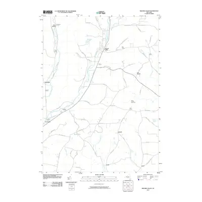
2010 Map of Newark Valley
USGS Topo · Published 2010About this map
Newark Valley serves as the central hub of this Tioga County landscape, where the East Branch Owego Creek and West Branch Owego Creek carve distinct valleys through the terrain. The settlement pattern is defined by several smaller hamlets including West Newark, East Newark, and Weltonville, each tied to the local creek systems. For those researching local lineages, the map is particularly dense with burial grounds such as Hope Cemetery, Saint Johns Cemetery, and the Settle Cemetery near the eastern margin. The southern portion of the quadrangle transitions into a more wooded environment, dominated by the Oakley Corners State Forest. Significant water features like Alexander Lake and Holden Pond punctuate the upland areas between the primary creek branches, illustrating the natural drainage that dictated early road placement and property lines.
Find a feature on this map
70 named features on this map. Tap any name to fly to it.
Don’t see what you’re looking for? This feature index may not catch every label — zoom into the map to look around manually.
Map Details
Editions of this 2010 Newark Valley Map
This is the sole edition of this map. No revisions or reprints were ever made.
Other maps of this area

1900 · Dryden
USGS Topo · 1:62,500

1901 · Apalachin
USGS Topo · 1:62,500

1903 · Owego
USGS Topo · 1:62,500

1903 · Harford
USGS Topo · 1:62,500

1904 · Apalachin
USGS Topo · 1:62,500

1906 · Catatonk
USGS Topo · 1:125,000

1949 · Speedsville
USGS Topo · 1:24,000
1949 · Lisle
USGS Topo · 1:24,000

1950 · Elmira
USGS Topo · 1:250,000
1950 · Richford
USGS Topo · 1:24,000