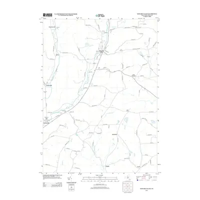
2013 Map of Newark Valley
USGS Topo · Published 2013About this map
Newark Valley serves as the central hub of this Tioga County landscape, where the E Br Owego Cr and several valley roads converge. The settlement pattern is defined by small, long-established hamlets including Weltonville, Hullsville, and Flemingville, each connected by a network of rural routes like Foster Valley Rd and Newark Valley Maine Rd. The area is notably dense with small burial grounds that provide a clear record of local family history, ranging from Saint Johns Cem near the town center to the more remote Settle Cem and Searlestown Cem. Water features like Alexander Lake and Little Nanticoke Cr punctuate the terrain, illustrating the importance of drainage and small water bodies to the development of these Upstate New York communities during their transition into the 21st century.
Find a feature on this map
98 named features on this map. Tap any name to fly to it.
Don’t see what you’re looking for? This feature index may not catch every label — zoom into the map to look around manually.
Map Details
Editions of this 2013 Newark Valley Map
This is the sole edition of this map. No revisions or reprints were ever made.
Other maps of this area

1900 · Dryden
USGS Topo · 1:62,500

1901 · Apalachin
USGS Topo · 1:62,500

1903 · Owego
USGS Topo · 1:62,500

1903 · Harford
USGS Topo · 1:62,500

1904 · Apalachin
USGS Topo · 1:62,500

1906 · Catatonk
USGS Topo · 1:125,000

1949 · Speedsville
USGS Topo · 1:24,000
1949 · Lisle
USGS Topo · 1:24,000

1950 · Elmira
USGS Topo · 1:250,000
1950 · Richford
USGS Topo · 1:24,000