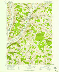
1956 Map of Newark Valley
USGS Topo · Published 1958About this map
Newark Valley serves as the focal point of this mid-century survey of Tioga County, where the valley floor of Owego Creek transitions into the dissected uplands of Irish Hill and Markham Hill. The landscape reveals a post-war rural economy defined by hilltop dairy farms and valley-bottom transportation corridors. The Lehigh Valley and Mc Lean Valley RR tracks trace the lower elevations, connecting smaller hamlets like Weltonville and Flemingsville to larger regional markets. Cultural landmarks of the era are well-documented, from the St Johns Ch and its neighboring St Johns Cem to the East Beecher Hill Community Club. Localized water features like Holden Pond and Little Nanticoke Creek punctuate the ridges, while numerous small cemeteries such as Pleasant Valley Cem provide essential data for genealogical research into the families who settled these Tioga County hollows.
Find a feature on this map
62 named features on this map. Tap any name to fly to it.
Don’t see what you’re looking for? This feature index may not catch every label — zoom into the map to look around manually.
Map Details
Editions of this 1956 Newark Valley Map
This is the sole edition of this map. No revisions or reprints were ever made.
Other maps of this area

1900 · Dryden
USGS Topo · 1:62,500

1901 · Apalachin
USGS Topo · 1:62,500

1903 · Owego
USGS Topo · 1:62,500

1903 · Harford
USGS Topo · 1:62,500

1904 · Apalachin
USGS Topo · 1:62,500

1906 · Catatonk
USGS Topo · 1:125,000

1949 · Speedsville
USGS Topo · 1:24,000
1949 · Lisle
USGS Topo · 1:24,000

1950 · Elmira
USGS Topo · 1:250,000
1950 · Richford
USGS Topo · 1:24,000