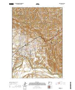
2020 Map of Newberg
USGS Topo · Published 2020About this map
Newberg and its surrounding agricultural and riverfront landscapes are documented here at the intersection of Yamhill, Washington, and Marion counties. The city's academic and aviation identity is clear, featuring the campus of George Fox University and the Sportsman Airpark. To the southwest, the Willamette River shapes the geography near Dundee, winding past Ash Island and the High Water Slough. The northern terrain is defined by the Chehalem Mountains and Laurel Ridge, where smaller communities like Rex and Springbrook sit along the slopes.
Find a feature on this map
196 named features on this map. Tap any name to fly to it.
Don’t see what you’re looking for? This feature index may not catch every label — zoom into the map to look around manually.
Map Details
Editions of this 2020 Newberg Map
This is the sole edition of this map. No revisions or reprints were ever made.
Other maps of this area

1916 · Tualatin
USGS Topo · 1:62,500

1923 · Mount Angel
USGS Topo · 1:62,500

1924 · Mc Minnville
USGS Topo · 1:48,000

1926 · Mc Minnville
USGS Topo · 1:62,500

1939 · Tualatin
USGS Topo · 1:62,500

1940 · McMinnville
USGS Topo · 1:62,500

1940 · Tualatin
USGS Topo · 1:62,500

1940 · Mount Angel
USGS Topo · 1:62,500

1941 · Yamhill
USGS Topo · 1:62,500

1942 · Yamhill
USGS Topo · 1:62,500