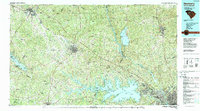
1986 Map of Newberry
USGS Topo · Published 1989About this map
Sumter National Forest dominates the northern reaches of this region, where the Enoree River and Tyger River converge amidst a network of rural settlements. Centered on the city of Newberry, the landscape is defined by the significant hydraulic engineering projects that reshaped central South Carolina. The expansive waters of Lake Murray stretch across the south, featuring islands such as Lunch Island and Dreher Island State Park, while the Monticello Reservoir and the Saluda River corridor illustrate the importance of water management to the local economy.
Find a feature on this map
180 named features on this map. Tap any name to fly to it.
Don’t see what you’re looking for? This feature index may not catch every label — zoom into the map to look around manually.
Map Details
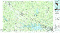
Editions of this 1986 Newberry Map
2 editions found
Historical Maps of Columbia Through Time
1 maps found