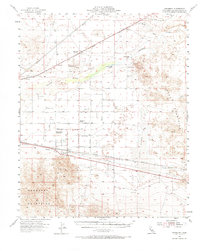
1955 Map of Newberry
USGS Topo · Published 1966About this map
Newberry Mountains and the Mojave River dominate this mid-century desert landscape, where transport and water define the layout of human activity. The map reveals a corridor of historical significance, showing the Union Pacific and Atchison Topeka and Santa Fe railroads traversing the arid terrain near settlements like Newberry and Harvard. An important local landmark, the Camp Cady (Site) near Cady Spring, marks the location of a former military outpost on the old Salt Lake Trail.
Find a feature on this map
29 named features on this map. Tap any name to fly to it.
Don’t see what you’re looking for? This feature index may not catch every label — zoom into the map to look around manually.
Map Details
Editions of this 1955 Newberry Map
3 editions found

Other maps of this area

1933 · Avawatz Mountains
USGS Topo · 1:250,000

1947 · Trona
USGS Topo · 1:250,000

1948 · Trona
USGS Topo · 1:250,000

1948 · Alvord Mountain
USGS Topo · 1:62,500

1948 · Cave Mountain
USGS Topo · 1:62,500

1948 · Lane Mountain
USGS Topo · 1:62,500

1951 · Cave Mountain
USGS Topo · 1:62,500

1951 · Alvord Mountain
USGS Topo · 1:62,500

1951 · Lane Mountain
USGS Topo · 1:62,500

1953 · San Bernardino
USGS Topo · 1:250,000