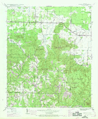
1945 Map of Newburg
USGS Topo · Published 1970About this map
The boundary between Franklin and Lawrence Counties cuts through a landscape defined by the deep ridges of the William B. Bankhead National Forest. This 1945 survey, updated in the late 1960s, documents a community-centered rural geography where life revolved around local congregations and crossroads. Settlements like Newburg and Atwood serve as anchors for a network of schools and churches including Piney Grove School and Kimbrough Chapel. The map reveals the early importance of historic transportation routes like the Byler Road and Old Byler Road, which follow the higher ground near the Tennessee Valley Ridge Area. Below these ridges, numerous hollows and creeks like Denton Hollow and Mud Creek illustrate the complex drainage patterns that shaped the early farms and homesteads of the region.
Find a feature on this map
49 named features on this map. Tap any name to fly to it.
Don’t see what you’re looking for? This feature index may not catch every label — zoom into the map to look around manually.
Map Details
Editions of this 1945 Newburg Map
2 editions found
Other maps of this area

1924 · Tuscumbia
USGS Topo · 1:48,000

1926 · Tuscumbia
USGS Topo · 1:62,500

1936 · Russellville
USGS Topo · 1:24,000

1936 · Newburg
USGS Topo · 1:24,000

1936 · Kinlock Spring
USGS Topo · 1:24,000

1936 · Phil Campbell
USGS Topo · 1:24,000

1936 · Moulton
USGS Topo · 1:48,000

1936 · Spruce Pine
USGS Topo · 1:24,000

1936 · Hatton
USGS Topo · 1:24,000

1936 · Landersville
USGS Topo · 1:24,000