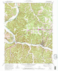
1992 Map of Newburg
USGS Topo · Published 1995About this map
Newburg sits at the confluence of Little Piney Creek and Mill Creek, serving as a focal point along the St Louis And San Francisco Rr. This rugged section of the Mark Twain National Forest is defined by the winding Gasconade River, where traditional river crossings such as the Boulware Ford (Abandoned) and Whitehouse Ford (Abandoned) have faded from active use. The map reveals a landscape of deep hollows like Glover Hollow and Poole Hollow, which historically dictated the placement of small community centers. Genealogists can find numerous family-linked landmarks, including the Ramsey Cem, Pillman Cem, and Kitchell Cem. Along the high ridges, Pea Ridge provides a natural corridor above the river valley, connecting smaller settlements like Jerome and Doolittle. The map also preserves the locations of local educational and religious centers such as Mungy Sch and New Home Ch.
Find a feature on this map
40 named features on this map. Tap any name to fly to it.
Don’t see what you’re looking for? This feature index may not catch every label — zoom into the map to look around manually.
Map Details
Editions of this 1992 Newburg Map
This is the sole edition of this map. No revisions or reprints were ever made.
Other maps of this area

1888 · Tuscumbia
USGS Topo · 1:125,000

1894 · Tuscumbia
USGS Topo · 1:125,000

1912 · Rolla
USGS Topo · 1:62,500

1936 · Waynesville
USGS Topo · 1:48,000

1937 · Vienna
USGS Topo · 1:62,500

1938 · Vienna
USGS Topo · 1:48,000

1942 · Waynesville
USGS Topo · 1:62,500

1944 · Waynesville
USGS Topo · 1:62,500

1947 · Jefferson City
USGS Topo · 1:250,000

1948 · Tavern
USGS Topo · 1:62,500