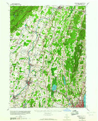
1946 Map of Newburgh
USGS Topo · Published 1964About this map
The Shawangunk Mountains and Marlboro Mountain frame a landscape defined by the winding Wallkill River and a dense network of early postwar settlements. This mid-century survey captures New Paltz and Walden before the full impact of suburban expansion, showing a region where agriculture and industry still operated in close proximity. Industrial markers like the Montgomery Worsted Mills and Gravel Quarry appear alongside recreation-focused landmarks such as the Wildmere House at Minnewaska and the Pine Point Casino on Orange Lake.
Find a feature on this map
96 named features on this map. Tap any name to fly to it.
Don’t see what you’re looking for? This feature index may not catch every label — zoom into the map to look around manually.
Map Details
Editions of this 1946 Newburgh Map
This is the sole edition of this map. No revisions or reprints were ever made.
Other maps of this area

1892 · West Point
USGS Topo · 1:62,500

1893 · Poughkeepsie
USGS Topo · 1:62,500

1894 · West Point
USGS Topo · 1:62,500

1894 · Poughkeepsie
USGS Topo · 1:62,500

1898 · Rhinebeck
USGS Topo · 1:62,500

1899 · West Point
USGS Topo · 1:62,500

1901 · West Point
USGS Topo · 1:62,500

1901 · Rosendale
USGS Topo · 1:62,500

1902 · Schunemunk
USGS Topo · 1:62,500

1903 · Poughkeepsie
USGS Topo · 1:62,500