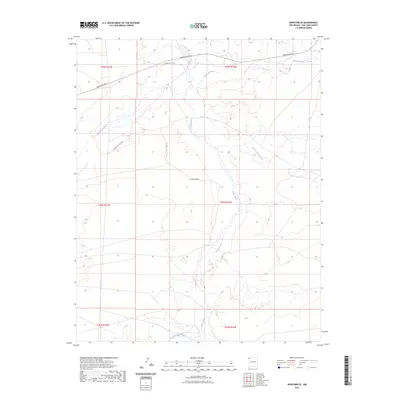
2023 Map of Newcomb SE
USGS Topo · Published 2023About this map
The Chaco River and its intricate network of ephemeral drainages dominate this arid landscape in San Juan County. This modern survey illustrates the natural hydrology of the region, where seasonal waters move through major channels like Brimhall Wash and Hunter Wash. The terrain is marked by traditional navigation routes, including Indian Svc Rte 5 and Indian Svc Rte 5008, which cross the high desert plateaus. These roads provide critical access through the various sections defined by the Public Land Survey System, such as t24n r16w and t25n r17w. Smaller watercourses, notably At-eec-ni-di-tso Wash and Arroyo Medio, weave between the larger washes, showing the delicate erosion patterns and geographic character of this high-altitude basin. The map serves as a contemporary record of how local infrastructure interacts with the desert's natural water-carved geography.
Find a feature on this map
15 named features on this map. Tap any name to fly to it.
Don’t see what you’re looking for? This feature index may not catch every label — zoom into the map to look around manually.
Map Details
Editions of this 2023 Newcomb SE Map
This is the sole edition of this map. No revisions or reprints were ever made.
Other maps of this area

1889 · Chaco
USGS Topo · 1:250,000

1892 · Chaco
USGS Topo · 1:250,000

1927 · Sulphur Spring
USGS Topo · 1:96,000

1928 · Kirtland
USGS Topo · 1:125,000

1932 · Kirtland
USGS Topo · 1:125,000

1954 · Shiprock
USGS Topo · 1:250,000

1958 · Shiprock
USGS Topo · 1:250,000

1959 · Shiprock
USGS Topo · 1:250,000
1966 · Sheep Springs
USGS Topo · 1:24,000
1966 · Newcomb NE
USGS Topo · 1:24,000