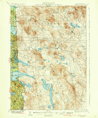
1937 Map of Newfield
USGS Topo · Published 1937About this map
Little Ossipee River flows through a landscape defined by industrial hamlets and glacial water bodies during the mid-1930s. This survey, compiled from work in 1889 and 1933, details the borderlands of Maine and New Hampshire, where the Salmon Falls River and several massive lakes like Great East Lake and Balch Pond dominate the western edge. Small village centers such as Ossipee Mills and Limerick appear alongside family-named landmarks like Wiggin Mountain and Mann Mountain. The distribution of rural landmarks, including the Spinney Ch and numerous remote ponds, reflects the late-depression era settlement patterns before modern development altered the rural character of York County. The map provides a distinct view of the transition from the rugged upland terrain of Hosac Mountain to the mill-driven economies of the lower valleys.
Find a feature on this map
66 named features on this map. Tap any name to fly to it.
Don’t see what you’re looking for? This feature index may not catch every label — zoom into the map to look around manually.
Map Details
Editions of this 1937 Newfield Map
3 editions found

Other maps of this area

1891 · Berwick
USGS Topo · 1:62,500

1891 · Kennebunk
USGS Topo · 1:62,500

1891 · Buxton
USGS Topo · 1:62,500

1891 · Newfield
USGS Topo · 1:62,500

1892 · Buxton
USGS Topo · 1:62,500

1893 · Kennebunk
USGS Topo · 1:62,500

1893 · Berwick
USGS Topo · 1:62,500

1893 · Buxton
USGS Topo · 1:62,500

1893 · Newfield
USGS Topo · 1:62,500

1896 · Sebago
USGS Topo · 1:62,500