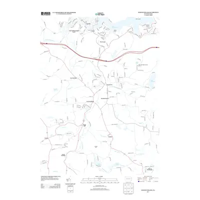
2013 Map of Newfoundland
USGS Topo · Published 2013About this map
Lake Wallenpaupack anchors the northern landscape of this region, where the residential developments of Lake Wallenpaupack Estate and The Escape meet the shoreline near Cairns Island. The map records a dense network of local roads and named settlements such as Newfoundland and Greentown, which are linked by the winding courses of the E Br Wallenpaupack Cr and W Br Wallenpaupack Cr.
Find a feature on this map
142 named features on this map. Tap any name to fly to it.
Don’t see what you’re looking for? This feature index may not catch every label — zoom into the map to look around manually.
Map Details
Editions of this 2013 Newfoundland Map
This is the sole edition of this map. No revisions or reprints were ever made.
Other maps of this area

1919 · Pocono
USGS Topo · 1:62,500

1921 · Pocono
USGS Topo · 1:62,500

1923 · Pocono
USGS Topo · 1:62,500
1924 · Bushkill
USGS Topo · 1:48,000

1928 · Ariel
USGS Topo · 1:62,500

1932 · Ariel
USGS Topo · 1:62,500

1935 · Hawley
USGS Topo · 1:62,500

1938 · Hawley
USGS Topo · 1:62,500
1943 · Bushkill
USGS Topo · 1:62,500
1943 · Pocono
USGS Topo · 1:62,500