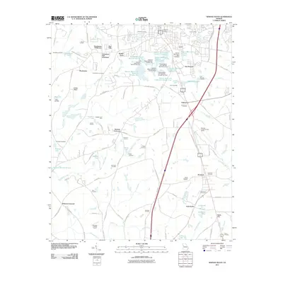
2011 Map of Newnan South
USGS Topo · Published 2011About this map
The Newnan-Coweta County Airport and the expanding residential corridors of East Newnan define the landscape south of the city center in the early 21st century. This survey documents the transition from suburban subdivisions like Smokey Acres and Hearthstone Subdivision to the rural crossroads of Stephens Crossroad and Bohanon Crossroad. A sophisticated system of water management is evident through numerous reservoirs, including Newnan Waterworks Reservoir Number Five and Pearl Lake.
Find a feature on this map
120 named features on this map. Tap any name to fly to it.
Don’t see what you’re looking for? This feature index may not catch every label — zoom into the map to look around manually.
Map Details
Editions of this 2011 Newnan South Map
This is the sole edition of this map. No revisions or reprints were ever made.
Other maps of this area

1953 · Atlanta
USGS Topo · 1:250,000

1957 · Atlanta
USGS Topo · 1:250,000

1958 · Atlanta
USGS Topo · 1:250,000

1964 · Hogansville
USGS Topo · 1:24,000

1964 · Grantville
USGS Topo · 1:24,000

1965 · Newnan South
USGS Topo · 1:24,000
1965 · Newnan North
USGS Topo · 1:24,000
1965 · Newnan SW
USGS Topo · 1:24,000
1965 · Whitesburg
USGS Topo · 1:24,000

1965 · Madras
USGS Topo · 1:24,000