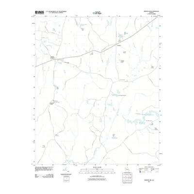
2011 Map of Newnan SW
USGS Topo · Published 2011About this map
Stallings Crossroad and Dresden anchor this rural landscape in southwest Coweta County, where small family cemeteries and local waterways define the community structure. The area is marked by a network of small reservoirs and dams, including Armory Creek Reservoir, Josephs Lake, and the tandem Blalock Lake Number One and Blalock Lake Number Two. These water bodies are fed by a dense system of branches and creeks such as Caney Creek, Mountain Creek, and Clear Creek, which eventually reach the New River at the southern boundary.
Find a feature on this map
71 named features on this map. Tap any name to fly to it.
Don’t see what you’re looking for? This feature index may not catch every label — zoom into the map to look around manually.
Map Details
Editions of this 2011 Newnan SW Map
This is the sole edition of this map. No revisions or reprints were ever made.
Other maps of this area

1899 · Wedowee
USGS Topo · 1:125,000

1902 · Wedowee
USGS Topo · 1:125,000

1953 · Atlanta
USGS Topo · 1:250,000

1957 · Atlanta
USGS Topo · 1:250,000

1958 · Atlanta
USGS Topo · 1:250,000

1964 · Hogansville
USGS Topo · 1:24,000

1964 · Hillcrest
USGS Topo · 1:24,000

1964 · Grantville
USGS Topo · 1:24,000
1964 · Franklin
USGS Topo · 1:24,000
1964 · Lowell
USGS Topo · 1:24,000