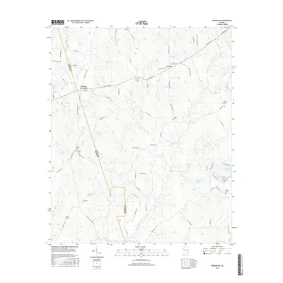
2017 Map of Newnan SW
USGS Topo · Published 2017About this map
Stallings Crossroad sits at the intersection of Coweta and Heard counties, anchoring a rural Georgia landscape defined by established family cemeteries and small community centers. To the east, Dresden serves as another focal point, situated near several significant religious sites including Emory Chapel Cem and Dent Chapel Cem. The terrain is characterized by a dense network of water bodies such as Blalock Lakes and Armory Reservoir, while the southern boundary follows the path of the New River. Genealogists will find a wealth of local markers throughout this quadrangle, from the isolated Ware Cem near the western border to the Wesley Chapel Cem in the northeast. The presence of the Board Rail Way in the southeast corner points to the area's logistical infrastructure, while named ridges like Buckeye Ridge reveal the subtle elevation shifts that dictate the local drainage into creeks like Mountain Creek.
Find a feature on this map
93 named features on this map. Tap any name to fly to it.
Don’t see what you’re looking for? This feature index may not catch every label — zoom into the map to look around manually.
Map Details
Editions of this 2017 Newnan SW Map
This is the sole edition of this map. No revisions or reprints were ever made.
Other maps of this area

1899 · Wedowee
USGS Topo · 1:125,000

1902 · Wedowee
USGS Topo · 1:125,000

1953 · Atlanta
USGS Topo · 1:250,000

1957 · Atlanta
USGS Topo · 1:250,000

1958 · Atlanta
USGS Topo · 1:250,000

1964 · Hogansville
USGS Topo · 1:24,000

1964 · Hillcrest
USGS Topo · 1:24,000

1964 · Grantville
USGS Topo · 1:24,000
1964 · Franklin
USGS Topo · 1:24,000
1964 · Lowell
USGS Topo · 1:24,000