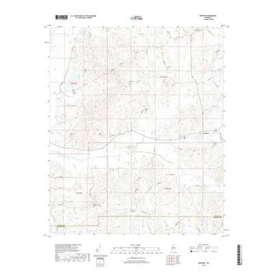
2018 Map of Newport
USGS Topo · Published 2018About this map
Newport sits at the eastern edge of this rural landscape, which is defined by a dense network of family and community burial grounds spread across the hill country of Attala and Madison counties. The terrain is deeply carved by numerous drainages, most notably Seneasha Creek and its many tributaries like Crooked Creek and Parker Creek. The map reveals a settlement pattern tied to these heights and hollows, where dozens of country roads, including County Road 4102 and County Road 4137, connect isolated church sites and cemeteries such as Harmonia Cemetery, Saint Mark Cemetery, and the Old Roby Cemetery. To the west, the land softens near Unger Ditch, while the southern reaches near the county line feature the Spring Grove Cemetery and Sandy Ridge Cemetery. This survey provides a meticulous record of the region’s social geography through its preserved landmarks and namesake creeks.
Find a feature on this map
64 named features on this map. Tap any name to fly to it.
Don’t see what you’re looking for? This feature index may not catch every label — zoom into the map to look around manually.
Map Details
Editions of this 2018 Newport Map
This is the sole edition of this map. No revisions or reprints were ever made.
Other maps of this area

1953 · Meridian
USGS Topo · 1:250,000

1953 · West Point
USGS Topo · 1:250,000

1957 · Meridian
USGS Topo · 1:250,000

1958 · West Point
USGS Topo · 1:250,000

1962 · Thomastown
USGS Topo · 1:62,500

1963 · West Point
USGS Topo · 1:250,000

1964 · Camden
USGS Topo · 1:24,000

1964 · Newport
USGS Topo · 1:24,000
1964 · Durant
USGS Topo · 1:24,000
1964 · Owens Wells
USGS Topo · 1:24,000