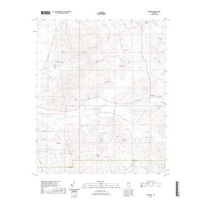
2020 Map of Newport
USGS Topo · Published 2020About this map
Newport sits along the northeastern edge of this central Mississippi landscape, characterized by a high density of rural family and community burial grounds that reveal the deep settlement history of the region. The map serves as a detailed record of local genealogy, identifying sites such as Pisgah Cem, Harmonia Cem, and Seneasha Cem. The drainage patterns are defined by the winding course of Seneasha Creek, which is fed by numerous tributaries including Crooked Cr, Parker Cr, and Steward Cr. In the southern portion of the sheet, the boundary between Attala and Madison Counties is visible, following a straight survey line that cuts across the natural hydrology of Deer Lake Cr. This network of country roads and creeks connects a series of small cemeteries, such as Wyatt Cem and Black Jack Cem, which often represent the only remaining markers of early homesteads and social centers.
Find a feature on this map
63 named features on this map. Tap any name to fly to it.
Don’t see what you’re looking for? This feature index may not catch every label — zoom into the map to look around manually.
Map Details
Editions of this 2020 Newport Map
This is the sole edition of this map. No revisions or reprints were ever made.
Other maps of this area

1953 · Meridian
USGS Topo · 1:250,000

1953 · West Point
USGS Topo · 1:250,000

1957 · Meridian
USGS Topo · 1:250,000

1958 · West Point
USGS Topo · 1:250,000

1962 · Thomastown
USGS Topo · 1:62,500

1963 · West Point
USGS Topo · 1:250,000

1964 · Camden
USGS Topo · 1:24,000

1964 · Newport
USGS Topo · 1:24,000
1964 · Durant
USGS Topo · 1:24,000
1964 · Owens Wells
USGS Topo · 1:24,000