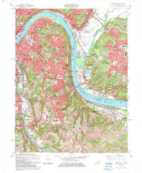
1983 Map of Newport
USGS Topo · Published 1984About this map
The Ohio River serves as the central artery for this 1980s landscape, where the urban expansion of Cincinnati meets the established communities of Northern Kentucky. The map documents a dense network of river-oriented infrastructure, including the Cincinnati Municipal Airport (Lunken Field) situated in the floodplains of the Little Miami River. Across the water, the Kentucky shoreline is defined by the high-elevation residential developments of Fort Thomas and Highland Heights, contrasted with the industrial and rail corridors of Newport and Covington along the Licking River.
Find a feature on this map
79 named features on this map. Tap any name to fly to it.
Don’t see what you’re looking for? This feature index may not catch every label — zoom into the map to look around manually.
Map Details
Editions of this 1983 Newport Map
2 editions found
Other maps of this area

1898 · East Cincinnati
USGS Topo · 1:62,500

1914 · East Cincinnati
USGS Topo · 1:62,500

1914 · West Cincinnati
USGS Topo · 1:62,500

1929 · Alexandria
USGS Topo · 1:48,000

1936 · Alexandria
USGS Topo · 1:62,500

1950 · Independence
USGS Topo · 1:24,000

1950 · Covington
USGS Topo · 1:24,000

1952 · Newport
USGS Topo · 1:24,000

1953 · Withamsville
USGS Topo · 1:24,000

1953 · New Richmond
USGS Topo · 1:24,000