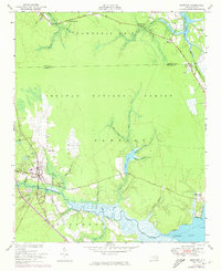
1951 Map of Newport
USGS Topo · Published 1973About this map
The town of Newport serves as a central hub on this coastal North Carolina landscape, where the Atlantic and North Carolina Railroad runs parallel to the Newport River. The map highlights a community deeply connected to its wetlands and waterways, with the Harlowe Canal cutting through the northeastern corner near Harlowe. Extensive tracts of the Croatan National Forest dominate the central terrain, while numerous branches and prongs, such as Ghouls Fork and Money Island Swamp, drain into the Mill Pond and the larger river system.
Find a feature on this map
56 named features on this map. Tap any name to fly to it.
Don’t see what you’re looking for? This feature index may not catch every label — zoom into the map to look around manually.
Map Details
Editions of this 1951 Newport Map
3 editions found

Other maps of this area

1949 · Havelock
USGS Topo · 1:24,000

1949 · Beaufort
USGS Topo · 1:24,000

1949 · Merrimon
USGS Topo · 1:24,000

1949 · Newport
USGS Topo · 1:24,000

1949 · Salter Path
USGS Topo · 1:24,000

1949 · Mansfield
USGS Topo · 1:24,000

1949 · Cherry Point
USGS Topo · 1:24,000

1949 · Core Creek
USGS Topo · 1:24,000

1949 · Masontown
USGS Topo · 1:24,000

1951 · Salter Path
USGS Topo · 1:24,000