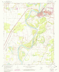
1962 Map of Newport
USGS Topo · Published 1982About this map
The town of Newport serves as a critical rail and river hub on this 1962 topographic survey, situated at a major bend in the White River. The Missouri Pacific railroad cuts through the landscape, linking settlements like Diaz and Nuckles to the industrial and commercial core of the city. Grounded in the early 1960s with 1980 revisions, the map reveals a complex aquatic landscape of oxbow lakes and sloughs such as Horseshoe Lake, Vance Lake, and Slaughter Pen Slough, illustrating the dynamic nature of the river delta. Genealogists can find numerous family-named landmarks and burial sites, including Walnut Grove Cem, Anthony Cem, and the Surrounded Hill Cem located near the prominent Surrounded Hill. Education and community life are marked by the presence of Castleberry Sch and Albright Sch, while the presence of an Airport (Abandoned) suggests shifts in regional transportation infrastructure.
Find a feature on this map
71 named features on this map. Tap any name to fly to it.
Don’t see what you’re looking for? This feature index may not catch every label — zoom into the map to look around manually.
Map Details
Editions of this 1962 Newport Map
3 editions found

Other maps of this area

1935 · Newport
USGS Topo · 1:62,500

1935 · Augusta
USGS Topo · 1:62,500

1935 · Tuckerman
USGS Topo · 1:62,500

1940 · Tilton
USGS Topo · 1:62,500

1953 · Memphis
USGS Topo · 1:250,000

1956 · Memphis
USGS Topo · 1:250,000

1956 · Tilton
USGS Topo · 1:62,500
1956 · Newark
USGS Topo · 1:24,000

1957 · Augusta
USGS Topo · 1:62,500

1962 · Jacksonport
USGS Topo · 1:24,000