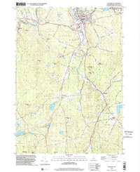
1998 Map of Newport
USGS Topo · Published 2002About this map
The South Branch Sugar River and the primary Sugar River converge in the town of Newport, New Hampshire, serving as the industrial and civic heart of this Sullivan County region. By the late 1990s, the landscape around the village center shows a dense network of local streets like Winter ST and Elm Street, alongside essential community landmarks including the Hospital, High Sch, and Town Hall. The transportation history of the area is visible in the Old RR Grade that follows the river west toward Chandlers Mills and Kellyville. Outside the main settlement, the terrain transitions into a patchwork of hills and water bodies, from Pikes Hill to Gilman Pond. Smaller hamlets like East Unity and Goshen Four Corners anchor the rural crossroads, while the Gallop Marsh State Wildlife Mgmt Area protects the wetlands to the south.
Find a feature on this map
70 named features on this map. Tap any name to fly to it.
Don’t see what you’re looking for? This feature index may not catch every label — zoom into the map to look around manually.
Map Details
Editions of this 1998 Newport Map
This is the sole edition of this map. No revisions or reprints were ever made.
Other maps of this area

1902 · Sunapee
USGS Topo · 1:62,500

1905 · Sunapee
USGS Topo · 1:62,500

1907 · Sunapee
USGS Topo · 1:62,500

1926 · Claremont
USGS Topo · 1:62,500

1927 · Bellows Falls
USGS Topo · 1:48,000

1929 · Claremont
USGS Topo · 1:62,500

1930 · Lovewell Mountain
USGS Topo · 1:62,500

1930 · Bellows Falls
USGS Topo · 1:62,500

1942 · Lovewell Mountain
USGS Topo · 1:62,500

1950 · Glens Falls
USGS Topo · 1:250,000